-
The platform does everything we’d want it to do. It is simple to use, the development team has been receptive to suggestions and the customer service is outstanding.
Sr. Product Design EngineerTop Utility Located in the Upper Midwest
-
Irth has consistently helped our company save millions of dollars a year by vastly reducing the number of crews we need to dispatch to our 811 locates.
VP of OperationsFortune 500 Telecommunications
-
I use this platform on an everyday basis. It is a very user-friendly tool. Dashboards, reporting, mapping and much more. The field locators tell me every week that they wish we had started using it long ago.
Regulatory Compliance EngineerTop Utility Located in the Southeast
-
This platform has taken our pipeline division from several manual paper/Excel processes to an automated, digital platform. Reports are easier to run, the platform is surprisingly flexible and customer support is wonderful.
Sr. Director of Operations and EngineeringFortune 500 Energy Company
Platform Overview
For decades, we have been leveraging the latest technology to assist our customers in ensuring the safety, resiliency, and reliability of their critical network infrastructure. We offer a wide range of features and technical capabilities encompassing damage prevention, risk analysis, and network infrastructure asset protection, all integrated into a powerful platform.


Using Augmented Reality to Prevent Damages to Critical Network Infrastructure
-
Lorem ipsum dolor sit amet.
-
Lorem ipsum dolor sit amet.
-
Lorem ipsum dolor sit amet.
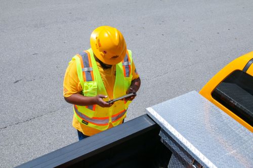

For Oil & Gas (Energy), Utilities (Electric & Gas) and Telecom Industries
Energy, utility and telecom companies have started embracing innovation and are moving to adopt the latest technologies. As these companies bring new technologies to their field users, there is strong interest in adopting augmented reality in damage prevention.
As a worker in the field, wouldn’t it be powerful to see what’s buried underground without digging? With innovative technologies such as augmented reality, it’s possible. Augmented reality technology has been available for more than 10 years (Microsoft, Google etc.). Apple made it possible and easier for end-users to view AR on their mobile phones. Understanding what virtual and augmented realities are and how they work is essential to realize how they can support damage prevention efforts.
Virtual reality is a computer-simulated experience that shows objects in three dimensions. This technology is often used in entertainment and training to simulate reality or a fictional world. From a locator and damage prevention standpoint, it allows you to create a hypothetical yet realistic environment where you can train and test the capabilities of field technicians.
Irth Solutions’ Locate Assurance offering (through our partner) uses virtual reality in its Virtual Locate Training Simulator to train locate technicians. Using this “in-office” virtual reality simulator, locate technicians can experience what it’s like in the field, encounter tricky scenarios in a “safe-to-fail” space and learn situations to avoid. This training improves safety, promotes best practices and reduces damages.
Augmented reality combines the real world or a photographic display of the actual world with computer-generated images to “augment” the visual view of reality.
AR apps use the camera on your mobile device to capture the real world and then add virtual objects to the scene so that you can view 3D representations on your screen. This eliminates the need for special equipment such as AR headsets.
Although humans gather information through all five senses, vision provides the most information to give clarity. That’s why we often say: A picture is worth a thousand words.
Our mental capacity or cognitive load limits the brain’s ability to absorb and process information.
With AR, you’re seeing something real using your eyes and can absorb and process the information without straining your cognitive load. When you don’t have vision, your brain must work hard to figure out what an object is for you to visualize it.
There are endless opportunities for businesses in energy, electric and gas utilities, and telecom to use augmented reality to protect critical infrastructure assets and identify risks. In damage prevention, AR aids in how we learn, perform work and make decisions:
- Learning: AR can enhance learning experiences, teach new skills faster and help people retain knowledge. Users don’t have to read text, they can access Irth Solutions AR app to view the assets and perform work since the underground assets are viewable. Irth Solutions AR Locate Assurance enables locators to be more effective in the field. The better trained locate technicians are, the less likely errors will be made in the field that threaten safety, damage or disrupt essential services.
- Efficiency: AR can change how we interact and perform work. Using AR, locate technicians can easily and quickly identify an underground asset. Augmented reality is a powerful tool that field workers can use to identify their asset quickly, get details of the asset and accurately perform the locate improving effectiveness and field efficiency.
- Support decision-making: Visualizing something and seeing it in 3D improves decision-making. When field technicians can “see” what’s underground, they can ensure accurate marks, resulting in fewer damages.
- Accuracy: Because the field technician uses a mobile device and UtiliSphere AR, the application provides phone-level accuracy for GPS to complete locates.
- Safety: By accurately locating underground assets by using AR, fewer damages occur that could potentially harm workers or communities.
UtiliSphere AR is simple and easy to use. Users in the field can click on Irth AR in the ticket detail page or AR icon from the GIS map and with couple of clicks can view the assets in real time. While working on a ticket, locators have access to all the ticket information and UtiliSphere AR. Locators can take a picture of the asset in AR view and attach it to the ticket. The locators also have ability to edit the picture using Irth’s drawing and sketching tool to draw, write, annotate or make any corrections for their internal GIS and operations teams.
UtiliSphere AR features:
- When working on a ticket, users can access augmented reality directly from the ticket, making it a powerful extension of the platform.
- Admins have project-based and utilities-based access to restrict who can access UtiliSphere AR and what users can view.
- The built-in measuring tool and map layer functionality give locators everything they need within the app.
- Provides easy-to-use calibration functions to ensure proper alignment of assets.
- Eliminates dependence on paper and 2D screens.
Whether it is helping locators identify assets faster or providing visibility to excavators before they dig, Irth Solutions Augmented Reality offering focuses on safety and protecting high risk assets from damage saving time, resources and money.
If you’re ready to see how augmented reality can improve your damage prevention efforts, contact us to schedule a demo of UtiliSphere AR.
Irth's market-leading SaaS platform improves resilience and reduces risk in the sustainable delivery of essential services that millions of people and businesses rely on every day. Energy, utility, and telecom companies across the U.S. and Canada trust Irth for damage prevention, training, asset inspections, and land management solutions. Powered by business intelligence, analytics, and geospatial data, our platform helps deliver the 360-degree situational awareness needed to proactively mitigate and manage risk of critical network infrastructure in a changing environment. Irth has been the top provider for 811 (one call) ticket management and utility locating software since 1995.
© 2024 Irth Solutions, L.L.C. All rights reserved | Terms of Service | Privacy Policy


